
GPS receivers and geolocation services typically provide vertical positioning based on a metric called Height Above Ellipsoid. That will tell you how high up you are relative to a theoretical model of the earth’s surface. With some additional context from geoid models, you can use HAE to find out how high you are above sea level.
While great for locating your vertical position on the ground, HAE and elevation above sea level aren’t very useful for finding out how high up you are in buildings or other structures. For that, you need an altitude measurement that measures your height based on the surrounding context. The figure below provides an example, where a person’s altitude doesn’t necessarily equate to their height above terrain.
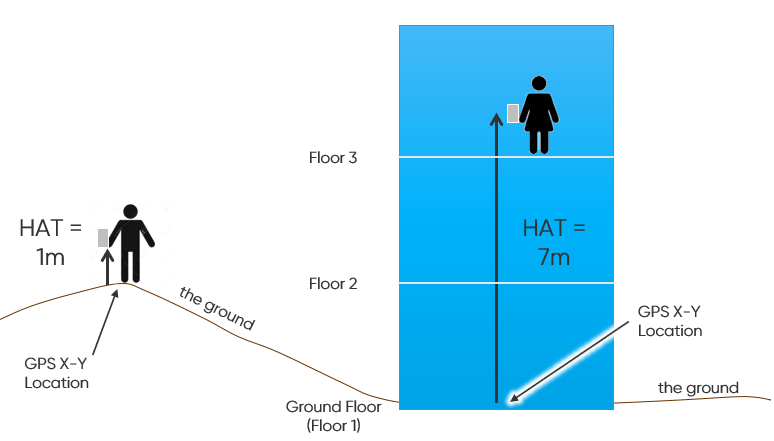
Some geolocation providers use Height Above Average Terrain (HAAT) to compare someone’s vertical location against where the ground is. Yet as the name suggests, HAAT is only an approximation of vertical location. Since it smooths out the significant changes in a certain area, HAAT is more of a best guess. In a place that’s really flat, HAAT might be close enough. In a place with hills of any appreciable size, HAAT is going to produce vertical measurements which aren’t very helpful.
Height Above Terrain (HAT)
That’s why here at NextNav we prefer to use a more precise measurement – Height Above Terrain. HAT compares publicly available survey data on vertical location above sea level at a certain location against our calculation of a person’s current location. The difference between those two places is the Height Above Terrain.
For example, if you’re on the 48th floor of the Transamerica Pyramid, your GPS device would place you at the x/y location of 37.7952° N, 122.4028° W. Running those coordinates against USGS survey data would tell us how high above sea level the ground floor of that building would be. Subtracting that from the current height of the device you’re holding would then allow us to calculate the Height Above Terrain.
While NextNav can definitively claim a certain level of accuracy for HAE, we can’t make the same claims for HAT data. The reason? The horizontal (x/y) location delivered by GPS may not be accurate enough. Since GPS signals are coming all the way from outer space, they don’t do very well in buildings and dense city blocks where buildings cast a signal shadow. In these cases, GPS signals are frequently inaccurate – often by quite a lot.
Let’s take another look at that Transamerica Pyramid example. If the horizontal GPS coordinates are off by fifty feet, it would put you in the Hilton across the street. Given the crazy hills of downtown San Francisco, the “ground level” of that Hilton is probably twenty feet higher than the ground level of the Transamerica Pyramid. If NextNav uses the USGS survey of the Hilton when you’re actually in the Transamerica Pyramid, it would put the Height Above Terrain two floors or more above where you actually are.
As technology improves and GPS alternatives like NextNav’s TerraPoiNT service are more widely deployed, horizonal location data will become more accurate. When that happens, NextNav’s ability to accurately calculate HAT will also improve.
Learn more about NextNav Pinnacle for vertical location and NextNav TerraPoiNT – our solution for position, navigation, and timing (PNT).